Overview of Manaslu Circuit Trek Map
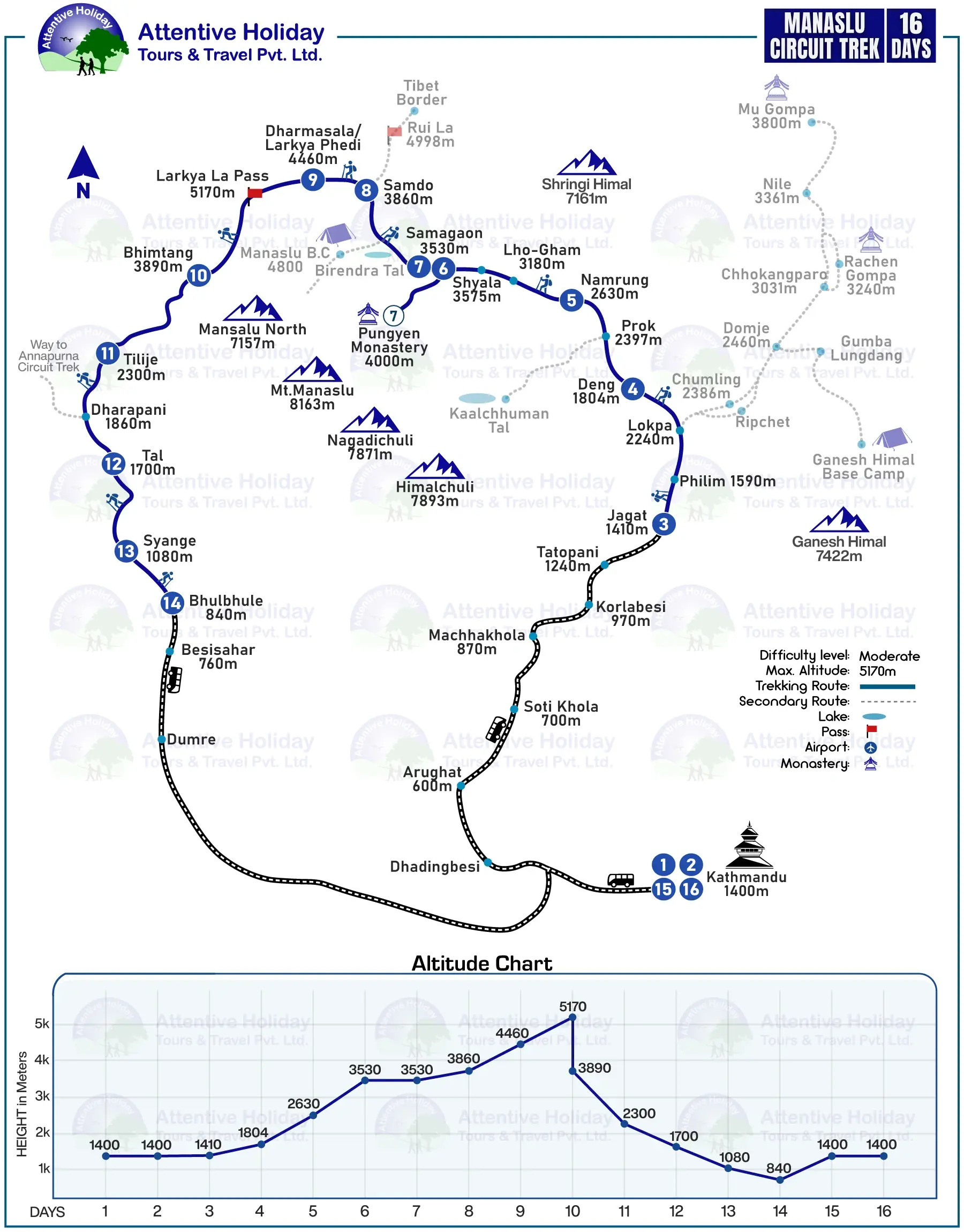
A Manaslu Circuit Trek Map is an important item that safely guides you through the remote and unknown high-altitude trails of Manaslu region. The Manaslu trekking map gives a visual overview of the entire Manaslu Circuit Trek region. It describes the trek starting point and the trek route passing through key villages with alternate routes with the help of pictures and symbols. A map is very important for locating yourself and your destination along a safe and established trekking path when going to a less-crowded region like the Manaslu circuit. Manaslu Circuit Trekking map shows the entire features of the trail starting at Machhakhola which is the trek starting point.
Manaslu Circuit Trek route map highlights all the cultural villages and overnight stops. It also features alternative routes to other destinations as a side trip during the trek. You should always get a map with distance to plan your itinerary and rest stops accordingly. Manaslu Circuit trek map with elevation lets you understand the daily altitude profile during the trek. It helps plan acclimatization days and avoid the risk of altitude sickness on such a high-altitude adventure. A good map with elevation chart, distance, secondary routes and overnight stops ensures safe navigation on established trails. Trekking with a map provides you information about the trekking region so you can plan your itinerary accordingly.
Since the region is remote and isolated, trekking with a proper Manaslu Circuit Trek map is very important. A map of Manaslu circuit helps you understand routes, acclimatization needs, rest points and daily distances for a safe trekking experience.
Manaslu circuit trekking map highlights maximum altitude, village stops and daily elevation profile. It also shows drivable road sections, trekking trail sections, entry and exit points, landmarks, mountain pass and side trips to Pungyen monastery, Manaslu Base Camp, Tsum Valley or even the Annapurna Circuit with clear symbolization. A good map should be easy to read and understand even by a beginner.
Trekking with a detailed Manaslu circuit trek map is a must whether you are a beginner or an experienced trekker. A Manaslu trek map is your companion during the Larkya La Pass trek. Carry a physical paper map of the Manaslu circuit or download an offline map in your mobile phone. It is better if you carry both the digital as well as a physical map for the trek as backup. You can also simply download the following detailed route map of the trek or save it as PDF to access it without internet.
Any type of Manaslu circuit trek map informs you with details of safe navigation, routes, landmarks and elevation throughout the trek. Learn about why a trekking map is so important for the Manaslu trek and what a detailed map should include for the trek. A map is not just a small tool or a piece of paper but is your blueprint for a successful and enjoyable Manaslu circuit trek.
Why is the Manaslu Circuit Trek Map important?
Manaslu Circuit Trek map is important because it helps a trekker to hike across the remote high-altitude region by providing a clear visual of routes, villages, altitude and symbols. You need a trekking map to safely complete the trek by following the right path and approach. A map shows everything from key landmarks, side routes to everything present on the main route. It is not just a navigation tool but is also a companion of trekkers.
Navigation
A map is primarily a tool for navigation. Manaslu circuit trekking map helps trekkers to explore the unknown paths of the high-altitude remote trails. It shows safe and correct trails where there are no established roads. A map navigates trekkers through villages until they cross the remote Larkya La Pass and still continues doing so til they reach the trek ending point.
Understanding routes
A map also helps in understanding the trekking routes in the Manaslu region. With the help of a map, you can identify the Manaslu circuit trekking route with other secondary routes leading to different destinations for side-trips. If you wish to extend your trip then you can understand the village or point from where you head into the secondary routes.
Learning about elevations during the trek
Manaslu circuit trek map helps you understand about the daily elevation on the trek. The map includes altitudes of all the villages and key landmarks to inform trekkers about how much elevation they will gain or lose. It is very important to avoid the risk of altitude sickness and include acclimatization days before climbing into high altitude sections.
Identifying cultural villages and rest stops
Manaslu trek map includes the names of villages during the trek as well as your overnight stops for the trek. You can learn about them and their culture beforehand with a quick search online. A map helps you identify rest stops after hiking each day.
What features should a Manaslu Circuit Trek Map have?
A trekking map is an important tool for proper navigation when trekking in the unknown, remote and isolated areas in the mountains. A good Manaslu Circuit Trek map should have the complete information about the trek and the region. Let’s look at the features that your Manaslu Circuit trek map should have.
- Clear visual of drivable road sections and the trekking section
- Exact trek starting and ending point
- Main Manaslu Circuit Trek route along with all possible alternative/secondary routes
- Daily elevation profile with an altitude chart
- All cultural villages, rest stops and acclimatization stops
- Rivers, lakes, mountain passes, monasteries, maximum altitude with proper symbols and an index
Manaslu Circuit Trek Route Map
Manaslu Circuit Trek Route map takes you to Machhakhola which is your trek starting point. From there you trek to Jagat. The circuit trek encircles the Manaslu massif and returns to Dharapani, which is normally the trek ending point. The route map for Manaslu trekking has clear information about the trails.
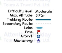
The map shows the complete route of the Manaslu circuit trek with other essential facts. You can see the names of cultural villages, overnight stops, driving routes, main trekking routes, secondary routes as well as important symbols. The Manaslu Circuit Trek map shows the difficulty level along with the maximum altitude that you reach during the trek. More importantly, the map includes an altitude chart to show daily elevation profiles during the trek. You can look at the index on the right side of the map to understand the symbols used in the Manaslu trekking map.
Does the Manaslu Circuit Trek Map show Alternative Routes?
A proper Manaslu Circuit Trek map shows all the possible side trips and alternative routes in the trekking region. Usually, alternative routes are called secondary routes on a map. If you look at the index on the map, you will see that secondary routes have a different symbol. They are usually symbolized by a dotted line instead of a continuous solid line. There are several alternative routes on the Manaslu circuit trek map which offers an extra-ordinary journey.
Tsum Valley route
By looking at the map, you can head towards the Tsum Valley by following the dotted secondary route leading to the village of Lokpa. Lokpa lies between Jagat and Deng and if you wish to add extra days by trekking in Tsum Valley, you need to take the secondary route. As per Manaslu Circuit trek map, the Tsum valley side route heads toward Chumling from Lokpa.
Kal Taal (Death lake)
The next secondary route on the Manaslu circuit trek map takes you to Kaalchhuman Taal which is famously known as Kal Taal (death lake). It is a sacred and remote alpine lake that is still quite hidden and unknown to mass tourism. As per the map, the side route to Kal Taal separates from Prok village. It lies between Deng and Namrung which are two overnight villages. A proper trekking map includes such a beautiful detour during the trek.
Pungyen Monastery
Manaslu Circuit Trek map indicates another beautiful alternative route to the sacred and high-altitude Pungyen Gompa (monastery). It is a Buddhist monastery that is believed to be the protector of Mount Manaslu. As per the map, you can take the side-trip hike to the monastery from the village of Samagaon. In fact most itineraries include this side-trip as an acclimatization hike.
Birendra Taal
Birendra Taal (lake) is another magnificent side route on the Manaslu circuit trek map. The alternative route takes you north from the village of Samagaon. It is an alpine freshwater lake that lies on the route to the base camp. This secondary route is scenic with a view of turquoise lake with snow-covered peaks as the backdrop.
Manaslu Base Camp
Manaslu circuit trek map shows a relatively close secondary route to the Birendra Taal. Actually the side trip to Manaslu Base Camp follows the same alternative trail past the lake. You need to take the detour from Samagaon to reach the base camp at 4,800 meters. Some take this detour as an acclimatization hike to reach higher elevations before sleeping at a lower height of 3,860 meters at Samdo.
Rui La Pass
From Samdo, Manaslu Circuit Trek map shows a secondary route branching off to the Rui la Pass (4,998m). It is a high-altitude pass that lies on the border of Nepal and Tibet in Manaslu trekking region. You need to leave the main trekking trail and head north from Samdo to hike to the Rui La Pass.
Annapurna Circuit route
The alternative route to Annapurna Circuit trek might be the most popular side trip on the Manaslu circuit trek map. This secondary route connects two popular circuit treks at Dharapani on the trekking map. Instead of descending to Besisahar, you head west from Dharapani and join the alternative Annapurna circuit trail route. This allows you to cross Larkya La and Thorong, two iconic high-altitude passes in different trekking regions.
Manaslu Circuit Trek Map with Distance
A clear Manaslu trek map with distance helps in navigation as well as planning for everyday’s hike. On the Manaslu Circuit Trek map, you can see various starting points which directly affect the toTaal distance of your trek. Due to road access, now the trek normally begins from Machhakhola. The toTaal distance of Manaslu Circuit trek lies around 140 to 145 km with Machhakhola as the trek starting point and Dharapani as the trek ending point. As the itinerary on the trekking map, the daily distances between route stops are as follows.
| Route | Distance in km (approx.) |
| Machhakhola to Jagat | ~20 |
| Jagat to Deng | ~21 |
| Deng to Namrung | ~19 |
| Namrung to Samagaon | ~18 |
| Samagaon to Samdo | 5 to 8 |
| Samdo to Dharmasala | ~7 |
| Dharmasala to Bhimtang with Larkya La Pass crossing | 15 to 24 |
| Bhimtang to Dharapani | 19 to 22 |
Manaslu Circuit Trek Map with Elevation
A Manaslu Circuit Trek map with elevation informs trekkers about the altitude profile during the trek with daily elevation gain or loss. A map with an elevation chart is really useful and important to learn about altitudes of overnight stops and avoid altitude sickness. It shows the maximum altitude that trekkers reach during a day which helps to understand the possibility of altitude sickness. It becomes easier to determine the need of acclimatization days at certain villages with the help of an elevation map during the Manaslu trek.
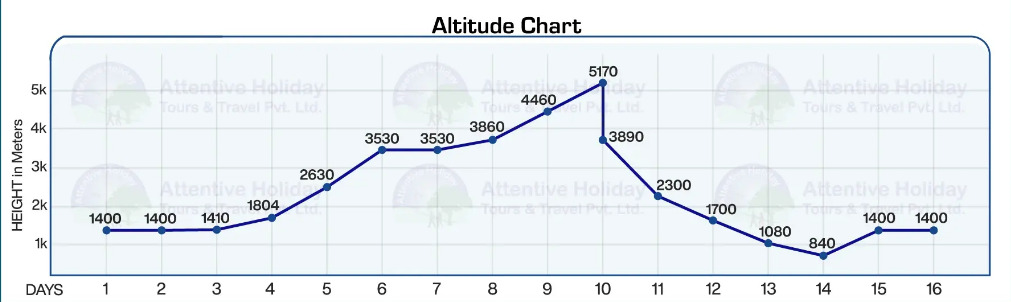
In addition to showing heights, the elevation chart indicates areas where altitude sickness risks may be higher. By looking at an elevation map, we can determine the need of acclimatizing in the village of Samagaon before the higher sections of Samdo and Larkya La Pass. You can learn about quick and sudden increases in altitude with a map with elevation which helps you prepare yourself in advance. You can plan your trek by looking at gradual ascents and route stops together with the help of a Manaslu circuit trek map with elevation.
Manaslu Circuit Trail Map
A Manaslu Circuit Trail map shows a visual route of the trek with all the villages, overnight stops, acclimatization points, passes, lakes, and so on. The trail map helps you locate the trailhead of the trek as well as the trek ending point. You will know the altitude of the villages and how the journey unfolds from lower villages, subtropical forests and enters the high altitude rugged terrain with glacial lakes and snow-covered pass.
On the Manaslu circuit trail map, the route features lower villages like Machhakhola, Jagat, Deng and Namrung. The mid sections include overnight stops like Samagaun which is an important acclimatization stop. As you can see, you can explore side routes from the village of Samagaun to Birendra lake as well. Then the higher sections include Samdo, Dharamshala and the Larkya La Pass itself before descending back to Dharapani and Besisahar.
Where can I get an offline map of the Manaslu Circuit Trek?
Manaslu Circuit Trek offline map shows the correct route with convenience without the need of the internet. You can get offline maps of the Manaslu Circuit Trek by downloading mobile applications like Maps.me, Organic maps or All trails, etc. Manaslu Circuit trek map is also available in Google maps where you can download the offline version too. However, you shouldn’t rely on google maps for such high-altitude remote trekking since they don’t provide topographic information, miss trail data and route. It is better to use real-time GPS based maps like Maps.me to get accurate digital maps of the region even without internet access.
Is it necessary to carry a physical Manaslu Circuit Trek Map?
Yes, carrying a physical map for the Manaslu Circuit Trek is helpful as a back up. In case the map on your device cannot be used then having a proper physical map with you helps you navigate the route and move ahead safely. Generally, we suggest trekkers carry printed maps as it is a reliable option while trekking in Nepal. Physical maps save you in higher regions where your devices may run out of battery leaving you without a navigation tool. Those paper maps take you along the established route regardless of internet access or your device. Such maps include a comprehensive outline of smaller communities, real-life scales and all the main as well as alternative routes as well. If you want to get a Manaslu Circuit Trek physical map, you can easily find them in trekking stores around Thamel.
Can I download the Manaslu Circuit Trek Map as a PDF?
Yes, you can download the Manaslu Circuit Trek Map as a PDF to keep it as a backup to your offline GPS map or physical map. Keeping a map of the Manaslu trek region as a PDF on your device can become very helpful during the trek with a minimal effort. With a PDF of the Manaslu Circuit Trek route map, you can get quick glimpses of the route and names of different villages with a clear image in case your physical map gets lost or damaged. Check out the Manaslu trekking map PDF with all essential trail information.
Essential tips on using the Manaslu Circuit Trek Map
A Manaslu trek map contains all the right tools for safe navigation and trail information. When used properly, a map becomes very useful outside of just locating the trails. Here are some expert tips to use your trekking map to its full extent.
Use both digital and physical maps
You should carry both offline digital maps as well as a physical paper map for your trekking journey. By combining both of them, you get real time data of your location and route while keeping the paper map as a backup if your devices die or stop working. Get the advantages of both maps and trek safely.
Learn to read the map properly
You should familiarize yourself with reading a map and understanding symbols, legends and scales. Before your trek, learn how to properly read a map so that you can identify villages, locate yourself, understand the main and side routes as well as get an idea of the altitude.
Ask locals about the route you see on the map
The conditions of the route that you see on a map can be very different in real life. You should ask around with locals about current trail conditions beforehand. They have the latest information and can help you avoid risky routes and areas due to natural causes. You don’t get such real time knowledge about the routes just from your map.
Track your daily elevation
Use your map to learn about daily elevation gain/loss. On this high altitude trek, it is important to track your elevation while hiking up from one stop to another to prevent altitude sickness. With the help of the altitude markers on the map, you should make informed decisions on the trail. If there is a high altitude stop on the map then you should acclimatize properly.
Use a map with acclimatization stops and alternative routes
You should use a map with acclimatization stops that inform you about the need to rest before trekking to higher altitudes. Samdo, Samagaun and Dharmasala are popular acclimatization stops on the trail before climbing to higher altitudes. Also, use a map that shows side trails and alternative routes. This helps you combine other destinations in the Manaslu region by trekking on an established and safe route.